Sites
Botetourt County Historical Society and Museum
Courthouse Square, 1 Main Street, Building 3, Fincastle, Virginia
Website
Driving Directions
Fincastle was one of the first communities in the original area of Botetourt County, founded in 1772. The town is an outdoor museum of late eighteenth- and early nineteenth-century American architecture. The Cumberland Gap Road (Fincastle Turnpike) was authorized to run between Fincastle and the Kentucky line in 1831. The museum building, located in Court House Square, was erected circa 1800. It serves as a repository for hundreds of artifacts that interpret the history of the county.
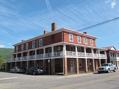
New Castle Historic District
New Castle, VA 24127
Website
Driving Directions
New Castle, Virginia · An outpost called “Craig’s Camp” was established here and visited by Col. George Washington in 1756 as he toured the frontier. This settlement, first called “Newfincastle,” became the county seat when Craig County was formed in 1851 from parts of six neighboring counties. The New Castle Historic District includes the Jeffersonian-style courthouse and the nearby Old Brick Hotel Museum.
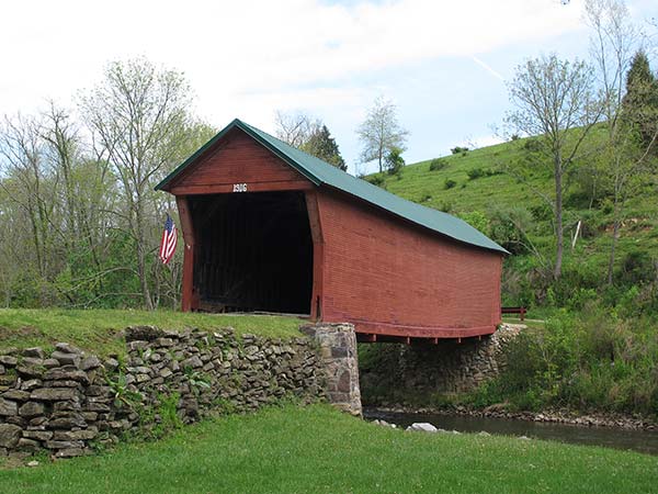
Clover Hollow Covered Bridge
348 Clover Hollow Road, Newport, Virginia
Website
Driving Directions
This small Burr-type covered bridge, built in 1916, is one of three surviving in the immediate vicinity of the village of Newport. Like the others, it is sided with horizontal weatherboards and supported by stone abutments. The town of Newport began in the early nineteenth century as an industrial center exploiting the abundant water resources available on the Greenbrier Branch in eastern Giles County.
Andrew Johnston House and Giles County Historical Society Museum
208 N Main Street, Pearisburg, Virginia
Website
Driving Directions
The town of Giles Court House, later Pearisburg, was established when Capt. George Pearis donated 53 acres in 1806. The brick Giles County Courthouse, built in 1836, dominates the town. The Giles County Historical Society’s Museum includes the 1829 Andrew Johnston House, a historic house museum which not only features numerous pieces of original furniture but contains rare examples of decorative wall painting.
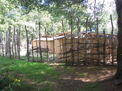
Wolf Creek Indian Village and Museum
6394 North Scenic Highway, Bastian, Virginia
Website
Driving Directions
Between 1490 and 1530 AD, a small group of Native Americans settled along Wolf Creek in present-day Bland County. They built a circular palisaded village to house as many as 100 people. Excavation of the site in 1970 revealed 14 structures and a wealth of artifacts. The Wolf Creek Indian Village and Museum opened in 1998 to interpret the story of the region’s prehistoric peoples, including a full recreation of the village.
Virginia Room at Tazewell County Public Library
Tazewell Historic District, 310 East Main Street, Tazewell, Virginia
Website
Driving Directions
The Tazewell County Public Library’s Virginia Room, located in the Tazewell Historic District, is intended to help visitors discover their family history in this region. The Virginia Room includes about 1500 volumes of published history, biography, records of the census, births, marriages, land transactions, tax assessments, wills, deaths, and cemeteries, newspapers, maps and gazetteers, as well as how-to guides to research.
Crab Orchard Museum and Pioneer Park/Fort Witten
3663 Crab Orchard Road, Tazewell, Virginia
Website
Driving Directions
Crab Orchard Museum presents not only local history but a comprehensive overview of the Appalachian region, with important exhibits on early life, military history, and a natural history section documenting the animals of Southwest Virginia. The museum’s exhibit of Native American artifacts displays the results of excavations at the nearby Crab Orchard site, a large Woodland village. Pioneer Park village includes fourteen log structures that have been reassembled to show what daily life was once like in western Virginia.
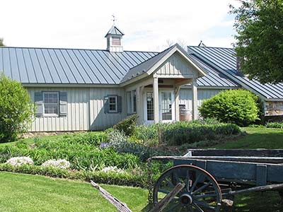
Tazewell County Visitor Center
200 Sanders Lane, Bluefield, Virginia
Website
Driving Directions
Completed in 1896, the restored Sanders House is now home to the Tazewell County Visitors Center. The large Victorian house features oak woodwork, an original mural, and original Sanders family collections. The property also contains a granary, smokehouse and cottage outbuildings, as well as the relocated historic Bailey House, a pre-Civil War log structure that was home to one of Bluefield’s earliest families.
Old Russell County Courthouse
North side of Alt. Rt. 58, .8 miles west of Rt. 665, Dickensonville, Virginia
Website
Driving Directions
This remarkable stone courthouse was built in 1799 by Henry Dickenson. It replaced a log courthouse that was burned during the Revolutionary War. A brick wing was added to the stone structure by the Robert Dickenson family between 1830 and 1850.
Breaks Interstate Park
627 Commission Circle, Breaks, Virginia
Website
Driving Directions
180 million years ago, the Russell Fork River began cutting a deep gorge through Pine Mountain between Virginia and Kentucky. Daniel Boone, his brother Squire, and Daniel Hill traveled through the Sandy Basin searching for a route to Kentucky and the Ohio River Valley in 1767. They found the gorge and named it “the Breaks”—the only passage through a 125-mile long stretch of impassable mountains. The gorge is home to rare plants such as fractal ferns, galax, colts foot, tea berries, and a profusion of fungi and moss species. The park, which caters to bikers, rafters, and horseback riders, spans the boundaries of Virginia and Kentucky.
Wise County Historical Society Room
250 of the Wise County Courthouse, Wise, Virginia
Website
Driving Directions
The Wise County Historical Society maintains an office and bookstore open daily to assist family history researchers. They have an extensive collection of research materials.
Old Fincastle Turnpike
Dungannon and Duffield, Virginia
Website
Driving Directions
The Cumberland Gap Road (known as the Fincastle Turnpike), authorized in 1831, was designed to give local farmers access to distant markets. Fincastle Church on Longhollow Road was originally constructed in Dungannon near the turnpike in 1876 by Samuel and Martha Blackwell. Rye Cove Brick Church was built in 1858 near Duffield. The rock retaining walls along the road in Rye Cove are said to have been built by enslaved African-American workers as part of the Fincastle Turnpike.Old Fincastle Turnpike Dungannon and Duffield, Virginia
The Cumberland Gap Road (known as the Fincastle Turnpike), authorized in 1831, was designed to give local farmers access to distant markets. Fincastle Church on Longhollow Road was originally constructed in Dungannon near the turnpike in 1876 by Samuel and Martha Blackwell. Rye Cove Brick Church was built in 1858 near Duffield. The rock retaining walls along the road in Rye Cove are said to have been built by enslaved African-American workers as part of the Fincastle Turnpike.